Mangrove Viability Index
This viability index is based only on the inundation and tidal connectivity of the site. This is a useful initial guess, but does not replace local knowledge and field data, and has some important limitations highlighted here. Do not assume that this indication of mangrove viability confirms site suitability for planting or restoration. Use this only as an initial scoping tool, and always validate all restoration intervention decisions with local knowledge and site data.
This layer is only generated if the AOI is close to globally identified mangrove habitats, if the input AOI is from a non mangrove region this layer will not be visible. This is an extremely high level check, and it is entirely possible that the layer is also generated for AOIs in regions without mangrove habitats. For this reason, you should be sure that mangroves are nearby before assuming this viability index is meaningful at all.
A critical aspect of site suitability that is not yet implemented in this viability check is local wave and wind energy. For this reason, the viability index will also highlight exposed beaches and intertidal regions which are absolutely not viable for mangrove restoration. If you look at the image below, the images circled in red are open and exposed beaches which are certainly not viable mangrove habitats.
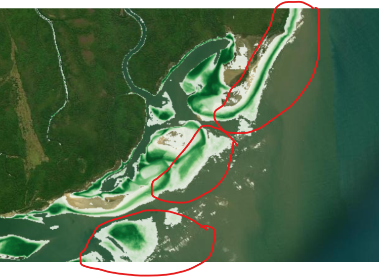
It is also important to be aware of site ecology, it is entirely possible that the site already serves another critical ecological niche such as tidal mudflats or intertidal seagrass, with other factors preventing mangrove establishment, and actively establishing mangroves at this site would serve to remove this critical non-mangrove habitat. Crucially, this layer does not factor in historical mangrove extent, as it is intended as a tool for scoping dynamic and changing sites where historical mangrove extent alone is not a reliable predictor of current site suitability. The current site ecology should be investigated, as this is a critical step for assessing site suitability for carbon projects and ensuring there is no destruction or change of existing critical habitats.
Methodology
The mangrove viability index is a combination of the per pixel inundation and tidal connectivity parameters. The viable inundation range is centred on 42.5% and ranges from 15% to 70%, based on the approximate range identified in Kumbier et al. (2021) as characteristic of mangrove and saltmarsh. Note that this is a wide and very general figure, and local species preferences are almost certainly different. This is combined with the tidal connectivity measure, so only regions with tidal connectivity and suitable inundation have a high mangrove viability index.
It is important to note that salinity also affects mangrove habitat niches, and this is typically dependent on distance from the open ocean in riverine mangrove habitats. Sites higher up river generally have lower salinity than sites closer to the coast, which will also affect site suitability.
Limitations & sources of error
- The empirical inundation range is site-specific. Kumbier et al. (2021) studied provide rough estimates of the inundation range; the 15–70% range may not transfer directly to the specific AOI tidal systems and ecology. Zonation and flooding tolerance vary considerably between species (e.g. Avicennia vs. Rhizophora).
- Only two factors. This index doesn't account for salinity, substrate type, wave energy, sediment supply, propagule availability, or existing competing vegetation which all need to be assessed before making a restoration intervention decision.
- Degradation causes The index only identifies open sites without vegetation with potentially viable hydrology. If there is no evidence of natural mangrove recruitment or establishment on the site, even with a nearby supply of propagules, this indicates there are further barriers to mangrove establishment which must be identified before making a restoration intervention decision.
References
- Kumbier, K. et al. (2021). Inundation characteristics of mangrove and saltmarsh in micro-tidal estuaries.
- Lewis, R. R. (2005). Ecological engineering for successful management and restoration of mangrove forests. Ecological Engineering, 24(4), 403–418.
- Worthington, T. A., & Spalding, M. (2018). Mangrove Restoration Potential: A global map highlighting a critical opportunity. IUCN / The Nature Conservancy.
Use in mangrove restoration
This is a very high level scoping tool to assess possible sites for mangrove establishment, based on their current site inundation and tidal connectivity. There are many other factors that need to be considered before assuming the site is truly viable for mangrove restoration, and the current barriers to natural mangrove establishment need to be well understood. This tool is intended only to support field data and local knowledge in reaching restoration intervention decisions.