Projected Sea Level Rise
The PDF report includes projections of local relative sea level rise from the IPCC Sixth Assessment Report (AR6), at the projection point nearest the site. Rising sea levels change inundation patterns over time: areas that are currently suitable for mangroves may become too wet, and areas that are currently too dry may become suitable. This is an important consideration for long-term restoration and carbon projects, in particular for long term carbon permanence.
The plot provided in the report is only the predictions at a single location, and is not used to map out how a site's inundation characteristics will change. It therefore can't be used directly to quantify how much of the site is at risk due to changing sea levels. However, if combined with local sea level calibrated topology data (with error's in the order of 10cm or less), site permanence risks can be mapped and quantified.
These values are taken from the IPCC AR6 relative sea level rise projections.
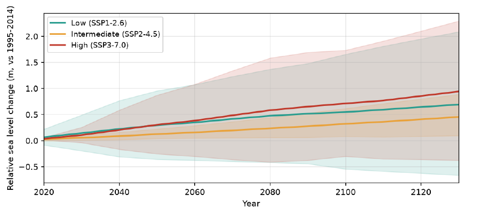
Plot interpretation
The plot shows the projected change in relative sea level from 2020 to around 100 years from now, compared to the 1995–2014 average, for three emissions scenarios:
- Low (SSP1-2.6) — strong reductions in greenhouse gas emissions.
- Intermediate (SSP2-4.5) — emissions continue around current levels until mid-century.
- High (SSP3-7.0) — emissions continue to increase.
Each line shows the median projection, and the shaded band shows the IPCC "likely" range (17th to 83rd percentile).
The table below the plot breaks down the 2100 projection for the intermediate scenario into its contributions: ocean thermal expansion and dynamics, glaciers, the Greenland and Antarctic ice sheets, land water storage and vertical land motion. Each value is the median of that contribution, so the contributions don't always add up exactly to the median total. Negative vertical land motion indicates the land is rising, which reduces the local sea level rise.
Methodology
The projections are the regional, medium-confidence projections of Garner et al. (2021), which accompany the IPCC AR6 report (Fox-Kemper et al., 2021), at the projection point nearest the centre of the AOI. The report states the distance between the AOI and the projection point. If there is no projection point within 300 km of the AOI, this section is left out of the report.
These are relative sea level projections: they include vertical land motion (subsidence or uplift), so they reflect the change in water level actually experienced at the coast.
Limitations & sources of error
- Single point. The projection is taken from the nearest projection point, which may be some distance from the site. Local vertical land motion, particularly subsidence in deltas and areas with groundwater extraction, can vary over short distances and may differ significantly from the projection.
- Medium confidence only. Low-likelihood, high-impact ice sheet processes are not included, so higher sea level rise than shown is possible, particularly after 2100.
- No change in tides or sediment. The projections show changes in mean sea level only. Changes in tidal range, storm surges, and sediment supply or accretion at the site are not included. Mangroves in particular can often trap sediment leading to accretion rates faster than predicted RSLR at some sites, so local mangrove accretion should be factored in for robust permanence assessments.
References
- Fox-Kemper, B. et al. (2021). Ocean, Cryosphere and Sea Level Change. In Climate Change 2021: The Physical Science Basis. Contribution of Working Group I to the Sixth Assessment Report of the Intergovernmental Panel on Climate Change. Cambridge University Press.
- Garner, G. G. et al. (2021). IPCC AR6 Sea Level Projections. Version 20210809. https://doi.org/10.5281/zenodo.5914709
Sea level rise and mangroves
Mangroves can keep pace with moderate sea level rise by trapping sediment and building up the soil surface, and by migrating inland where there is space to do so. Sites with low sediment supply, or where landward migration is blocked by levees, roads or development, are more vulnerable. For long-term restoration projects, consider whether the site has room to migrate inland, and whether the current inundation will remain suitable under the projected sea level rise.